


Please use this identifier to cite or link to this item:
http://www.infoteca.cnptia.embrapa.br/infoteca/handle/doc/995480| Title: | MAPA de cobertura vegetal e uso da terra da área piloto de Apuí - Amazonas: folha: Fazenda Guanabara. |
| Date Issued: | 2000 |
| Citation: | [Belém, PA]: Embrapa Amazônia Oriental: IPAAM, 2000. |
| Thesagro: | Cobertura vegetal Vegetação Solo |
| Keywords: | Apuí Fazenda Guanabara Rio das Pombas Rio Preto Amazonas |
| Notes: | Equipe técnica: Tarcísio Ewerton Rodrigues, Marcelo Cordeiro Thales, Antonio Guilherme Soares Campos, Sandra Maria Neiva Sampaio. |
| Type of Material: | Mapas |
| Access: | openAccess |
| Appears in Collections: | Outras publicações (CPATU)  |
Files in This Item:
| File | Description | Size | Format | |
|---|---|---|---|---|
| UsoeCoberturaVegetaldaFolhaGuanabaranaAreapilotodeApui.pdf | 563,02 kB | Adobe PDF | 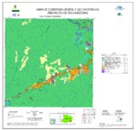 View/Open |


