


Please use this identifier to cite or link to this item:
http://www.infoteca.cnptia.embrapa.br/infoteca/handle/doc/991970| Title: | MAPA de cobertura vegetal e uso da terra do Município de Silves - Estado do Amazonas. |
| Date Issued: | 2003 |
| Citation: | [Belém, PA]: Embrapa Amazônia Oriental: SUDAM, 2003. |
| Thesagro: | Cobertura vegetal Vegetação |
| Keywords: | Silves Rio Amazonas Rio Anebá Lago Canaçari Amazonas |
| Notes: | Parte de: SILVA, J. M. L. da; RODRIGUES, T. E. Zoneamento agroecológico do município de Silves - AM. Belém, PA: Embrapa Amazônia Oriental, 2003. 38 p. (Embrapa Amazônia Oriental. Documentos, 174). |
| Type of Material: | Mapas |
| Access: | openAccess |
| Appears in Collections: | Outras publicações (CPATU)  |
Files in This Item:
| File | Description | Size | Format | |
|---|---|---|---|---|
| Doc174mapa5.pdf | 15,12 MB | Adobe PDF | 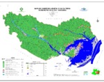 View/Open |


