


Use este identificador para citar ou linkar para este item:
http://www.infoteca.cnptia.embrapa.br/infoteca/handle/doc/991965| Título: | MAPA de aptidão agrícola das terras do Município de Silves - Estado do Amazonas. |
| Ano de publicação: | 2003 |
| Referência: | [Belém, PA]: Embrapa Amazônia Oriental: SUDAM, 2003. |
| Thesagro: | Aptidão agrícola |
| Palavras-chave: | Silves Rio Amazonas Lago Canaçari Rio Anebá Amazonas |
| Notas: | Parte de: SILVA, J. M. L. da; RODRIGUES, T. E. Zoneamento agroecológico do município de Silves - AM. Belém, PA: Embrapa Amazônia Oriental, 2003. 38 p. (Embrapa Amazônia Oriental. Documentos, 174) e SILVA, J. M. L. da; RODRIGUES, T. E. Avaliação da aptidão agrícola do Município de Silves - Estado do Amazonas. Belém, PA: Embrapa Amazônia Oriental, 2003. 25 p. (Embrapa Amazônia Oriental. Documentos, 177). |
| Tipo do Material: | Mapas |
| Acesso: | openAccess |
| Aparece nas coleções: | Outras publicações (CPATU)  |
Arquivos associados a este item:
| Arquivo | Descrição | Tamanho | Formato | |
|---|---|---|---|---|
| doc174mapa2.pdf | 13,2 MB | Adobe PDF | 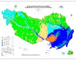 Visualizar/Abrir |


