


Use este identificador para citar ou linkar para este item:
http://www.infoteca.cnptia.embrapa.br/infoteca/handle/doc/993899| Título: | MAPA de vegetação e uso da terra do Município de Irituia - Pará. |
| Ano de publicação: | 2000 |
| Referência: | Belém, PA: Embrapa Amazônia Oriental: SUDAM, 2000. |
| Thesagro: | Vegetação Cobertura vegetal Uso da terra |
| Palavras-chave: | Irituia Rio Irituia Rio Guamá Pará |
| Tipo do Material: | Mapas |
| Acesso: | openAccess |
| Aparece nas coleções: | Outras publicações (CPATU)  |
Arquivos associados a este item:
| Arquivo | Descrição | Tamanho | Formato | |
|---|---|---|---|---|
| CoberturaVegetaldoMunicipiodeIrituia.pdf | 685,4 kB | Adobe PDF | 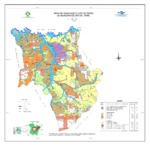 Visualizar/Abrir |


