


Use este identificador para citar ou linkar para este item:
http://www.infoteca.cnptia.embrapa.br/infoteca/handle/doc/995283| Título: | MAPA de cobertura vegetal e uso da terra do Município de Capixaba, Estado do Acre. |
| Ano de publicação: | 2001 |
| Referência: | [Belém, PA]: Embrapa Amazônia Oriental, 2001. |
| Thesagro: | Cobertura vegetal Uso da terra |
| Palavras-chave: | Capixaba Rio Acre Rodovia BR - 317 Acre |
| Tipo do Material: | Mapas |
| Acesso: | openAccess |
| Aparece nas coleções: | Outras publicações (CPATU)  |
Arquivos associados a este item:
| Arquivo | Descrição | Tamanho | Formato | |
|---|---|---|---|---|
| CoberturaVegetaleUsodoSolodoMunicipiodeCapixaba.PDF | 1,54 MB | Adobe PDF | 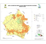 Visualizar/Abrir |


